This composite map is based upon maps from Peoples Temple documents, from descriptions in the Roller Journals, and from survivors’ remembrances. We welcome additional details from other former Jonestown residents.
More descriptions appear below the map, as well as the main source map. In addition, a detailed inventory of Jonestown’s facilities made a week after the deaths – the report of a walking tour of the community by an Embassy official – appears here.
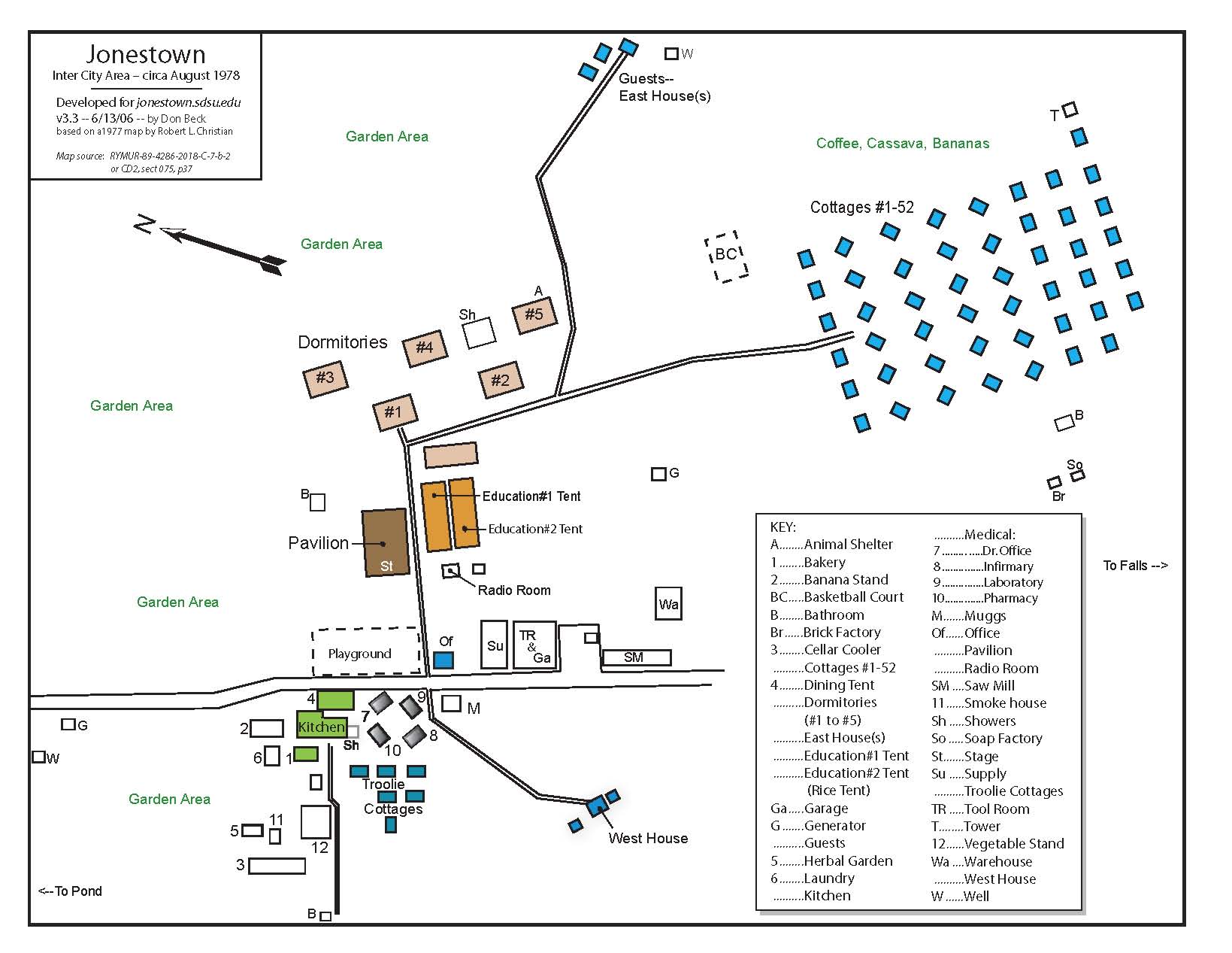
The pavilion (middle left on map) was the main meeting area. It was an open-air structure with a stage at one end, benches and chairs for meetings, entertainment and activities of the whole group together. It was around this structure that most Jonestown residents died on 18 November 1978.
48 cottages in eight rows of six (upper right of map). Cottages had from 10 to 20 people with combinations of double, triple bunks, and other beds on a main level. Some cottages had beds for two to four more people in an upper loft area. Each person had the wooden locker they brought with them. Each cottage had a porch and chairs for sitting outside.
Five dormitories (also called apartments) near the main pavilion. Dorm #1 was for the toddlers and pre-school children. Under Dorm #5 was an animal refuge for wild animals rescued and being cared for.
There were six cottages called troolies with walls made from woven troolie reeds/leaves. Pop and Luvena Jackson, Lisa Layton and other seniors stayed here, as did Marceline Jones near the medical offices.
The dining tent, kitchen and bakery were together next to the road. The banana stand, where bananas were hung to ripen, was here too. Behind here as well was the laundry with washers and driers which used heat from the kitchen to dry things.
Further behind the kitchen area was the vegetable stand for storing, sorting and preparing fresh foods, the herb center, a smoke house and sunken cellar cooler.
West House (lower middle of map) where Jim Jones and staff stayed.
Several guest cottages – also referred to as East House, where Jim Jones first stayed – were further up the path past the dormitories, just at the middle top of the map.
The radio room was near the pavilion and tents.
Educational Tents 1 & 2, next to the pavilion, were used for school classes, as well as housing the library. Tent 2 was at one time called the Rice Tent where rice was stored and sorted for the kitchen.
The four medical buildings included the doctor’s office, infirmary, laboratory and pharmacy. One of the next construction projects was to build an infirmary with more beds.
Storage and workshops, including the tool shop and garage, saw mill and woodshop, supply, and warehouse were also centrally located.
The office was Charlie and Joyce’s cottage with Mr. Muggs’ cage just across the street from it.
There were several bathrooms and showers to serve the residences. There were several generator buildings and wells.
Near the cottages was a basketball court. The brick factory and soap factory were in the field below the cottages.
Other buildings not shown on the map on the road in from the Mathews Ridge-Port Kaituma Road include the piggery, barns with cattle and horses, and the chickenry, where chickens were raised for food and to lay eggs. Go here for weekly agricultural reports to get an idea of production levels that had been achieved.
Surrounding all the buildings, the cleared land was mostly planted in fields and orchards, with citrus trees, coffee, mangos, bananas, sweet potatoes, eddoes, rice, papaya, and vegetable gardens (greens, beans, okra, cabbage, and more). Several kinds of cassava were also extensively grown, for example, along the road into Jonestown.
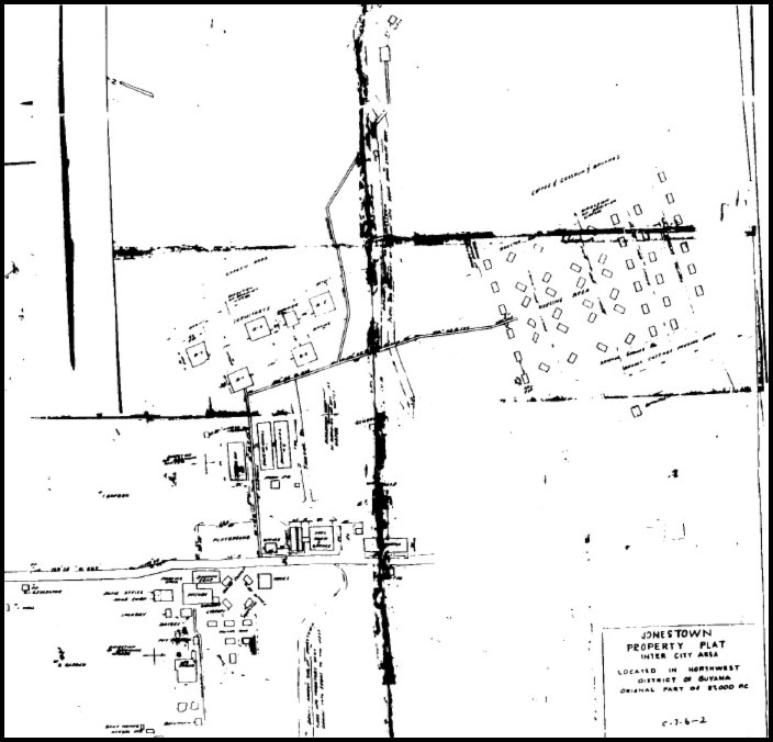
Original Map shown below. If a better copy or original paper map can be obtained, many dimensions and detail notes could be read.[1]
Originally posted on July 25th, 2013.
Last modified on June 17th, 2023.